Project description
This project was previously known as the Lakeshore Royal Windsor Hydro One Corridor Multi-Use Trail.
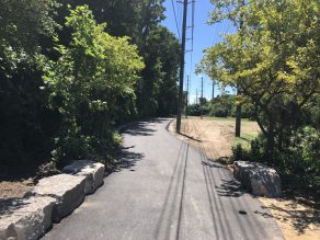
This project provides a new off-road trail within the Hydro One Corridor. The trail is approximately 12 kilometres long and extends from Winston Churchill Boulevard to Westfield Drive, with some on-road connections. This is a joint project between the City of Mississauga and the Region of Peel in conjunction with Hydro One Network Inc.
The trail provides an important east-west connection in the city. It is part of Mississauga’s plan to provide active recreational opportunities for people and connections to other areas and trails.
In June 2019, Council approved that this trail be named “Nine Creeks Trail.” The name Nine Creeks Trail recognizes the various creeks that intersect the trail through some of Mississauga’s oldest and most established neighbourhoods. The completed trail has crossings at Sheridan Creek, Turtle Creek, Birchwood Creek main branch, Birchwood Creek secondary branch, Lornewood Creek, Stavebank Creek, Kenollie Creek, Mary Fix Creek and Cooksville Creek.
The City designed the trail to meet the Accessibility Standards for the Design of Public Spaces, making it safe and inclusive for all.


Public engagement
Ward 2
- February 25, 2014 – Clarkson Secondary School
- February 27, 2014 – Lorne Park Library
- March 28, 2017 – Lorne Park Secondary School (Councillor initiated meeting)
Wards 1 and 7
- June 24, 2015 – Saint Hilary Church
- June 30, 2015 – Applewood United Church
Community information meeting
- November 10, 2016 – Lorne Park Secondary School, Cafeteria (Ward 2)
Construction staging
Ward 2
Completed and open to the public:
- Phase 1 (July 2018): Lorne Park Road to Indian Road
- Phase 2 (July 2018): Truscott Drive to Lorne Park Road
- Phase 3 (September 2018): Ravine Drive to Whiteoaks Avenue
- Phase 4 (June 2019): Welwyn Drive to Clarkson Road
- Phase 5 (June 2019): Bromsgrove Road to Southdown Road
- Phase 6 (August 2019): Southdown Road to Welwyn Drive
- Phase 7 (October 2019): Whiteoaks Avenue to Truscott Drive
- Phase 8 (June-November 2019): Woodeden Drive and Indian Road to South Sheridan Way
- Phase 9 (August 2019): Clarkson Road to Ravine Drive
- Phase 10 (October 2019-July 2020): Winston Churchill Boulevard to Bromsgrove Road
Ward 1
Completed and open to the public:
- Phase 11 (August 2019): Cawthra Road to Westfield Drive
Ward 7
Completed and open to the public:
- Phase 12 (August 2019): Cliff Road to Asta Drive
- Phase 13 (March 2020): North Service Road to Camilla Road
- Phase 14 (April 2021-July 2021): Camilla Road to Cliff Road
Future project phase: Nine Creeks Trail connection over Credit River
A separate trail project, approximately one kilometre long, is underway to connect the west and east parts of the Nine Creeks Trail with a bike-pedestrian crossing over Credit River.
The project is scheduled to begin construction in 2025 and anticipated to be completed in 2027. Once the bridge is complete and deemed safe, it will be opened to the public.
Questions and answers
The City is sharing the costs 50/50 with the Region on Peel. The City pays for the trail from a tax levy, $21,735; the rest is funded by Regional and Provincial Grants as well as development charges.
The City held multiple public engagements for this project in Ward 1, 7, and 2 (please see the Public Engagement section above). In addition, construction notices were sent to Ward 2 residents whose property is within 120 metres from the trail in March 2018. Ward 1 and Ward 7 residents will receive notices closer to the date of construction. The City has also had a detailed trail alignment plan posted on the Parks and Forestry website for one year prior to construction commencement.
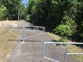
The City will install regulatory signage prohibiting motorized vehicles on the trail. They will also be installing offset gates which will allow for wheelchairs, pedestrians, strollers, bicycles to pass through the gates, preventing access to motorized vehicles.
Although many people use the hydro corridor, technically, Hydro One Inc., considers this trespassing on their lands. Once the City finishes the multi-use trail construction, residents will be able to safely use the trail for walking, biking, running and other passive uses.
The City must install temporary construction fencing to protect the public during the trail construction. The construction fencing will be removed as soon as the trail section between is completed, inspected, deemed safe and ready for its intended purpose—the public use and enjoyment.
The City considers this a public safety issue and wants to ensure that all construction is completed before opening a section of trail to the public. If construction sequence and schedule change, the City will reopen unaffected corridor sections if they are safe for walking.
The City will only remove the vegetation where the new trail will be constructed and over the next three years the City will be managing additional restoration plantings along the trail.
The meandering trail design is for two main reasons. First, the mandatory offset from any hydro pole is 15 metres. Therefore, the trail runs in at the centre wherever possible and wraps around the poles to maintain the offset. There are also other utilities such as two major pipelines and the City has tried to avoid them with this design.
The other reason for this design is that a meandering trail is more visually appealing than a straight line.
Yes. The trail design is in compliance with the approving agencies’ regulations as well as was reviewed and approved by all required authorities.
Coyote sightings are common in Mississauga and surrounding areas. Learn more about coyotes and view an interactive coyote sighting map.