About
We’re rehabilitating and improving the roadway around Bert Fleming Park to make it safer and accessible for all road users.
The design and construction work for this project will be bundled with various road improvement and renewal projects, improving efficiency and cost. This means that construction only needs to happen once.
The project will result in these improvements and renewals:
- Rehabilitated roads
- Improved intersections
- Increased road safety
- New transit infrastructure
- Renewed landscaping
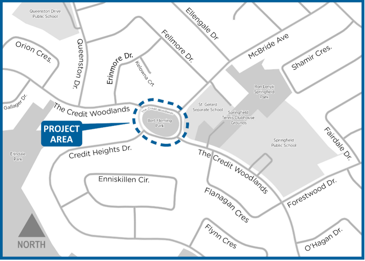
The project area includes the roadway around Bert Fleming Park. A map illustrating the project area is available.
These improvements will make it easier to get around, whether you’re walking, cycling, taking public transit or driving. At the same time, these improvements will help keep our community vibrant, active and safe. They will also support the City’s Vision Zero Action Plan as they prioritize the safety and access of our most vulnerable road users.
Project status
Preliminary design is currently in progress. Construction is scheduled to begin in the spring of 2025 and to finish in the fall of 2025.
Why The Credit Woodlands is being redesigned
The original rotary around Bert Fleming Park (often referred to as a “traffic circle” by the community) doesn’t meet modern design standards. Although the design is familiar to local residents, it fails to slow traffic, is missing pedestrian crossings and causes confusion for drivers. To address these issues and complete necessary road surfacing work, we’re redesigning the project area.
Regardless of the Sharing Lanes project, the review of the roadway layout would have been triggered by the necessary resurfacing work.
Outcomes from the temporary redesign
In summer of 2023, we made temporary design changes to the roadway, as part of the Sharing Lanes project. These changes were based on feedback collected through community engagement sessions. Changes applied and the results include the following.
- By replacing two traffic islands with all-way stops, we changed how cars move around Bert Fleming Park.
- We added six new crosswalks, and doing so helped to connect the park with two nearby schools. This improved the safety of students and families walking to and from school.
- Converting the west portion of the rotary into a car-free plaza provided new space for locals to use as an extension of the park.
Data and feedback-based permanent solutions
Through the Sharing Lanes program, we collected data and resident feedback on the impact the temporary changes had on all road users in the area. The feedback was mixed, but showed several key themes:
- Appreciation for the improved pedestrian crossing and reduced traffic speeds.
- Concerns about the interrupted traffic flow caused by the new all-way stops.
- Desire to see the neighbourhood character returned to its original state by removing road art and using standard pavement markings and signage.
- Enjoyment of the car-free plaza, particularly by children and families.
The permanent redesign of the roadway is based on the feedback collected through previous public consultations. It prioritizes improvements that will enhance safety and accessibility for all road users, while respecting the character of the neighbourhood.
Independent review of reimplementing a rotary design
An engineering consultant conducted a thorough review to determine if the roadway around Bert Fleming Park could be returned to the original rotary design. The review found that a rotary design does not meet current engineering guidelines and introduces safety concerns. You can read the complete report online.
Design alternatives
The City and its engineering consultant completed a detailed analysis that determined that the roadway around Bert Fleming Park cannot be restored to its previous state. The previous configuration does not meet today’s road design guidelines and creates issues related to speeding, operational confusion, pedestrian crossing and access. You can read the complete report of the review.
For these reasons, we explored several potential design alternatives to address the concerns and improve the project area. Design alternatives are different options for completing an infrastructure project.
A total of 10 design alternatives were considered. Out of the design alternatives considered, two potential designs aligned close to the feedback we got from residents:
- Roundabout that meets modern-day design guidelines
- Modification of the original configuration with two mini-roundabouts
Roundabout design alternative
This alternative features a roundabout that meets modern-day design guidelines. This includes specific design and traffic control features, such as:
- Large entry angles
- Crosswalks
- Splitter islands
- Parking restrictions
- No driveway access
This design meets modern standards, would make the road safer and slow down cars when they enter and exit the road around Bert Fleming Park. However, it would also mean:
- Critical impacts to vehicular access for several existing residents make this alternative not technically feasible
- Loss of Bert Fleming Park, including the opportunity to redevelop the park to benefit the community
- Significant and costly modifications to the road, related infrastructure and utilities
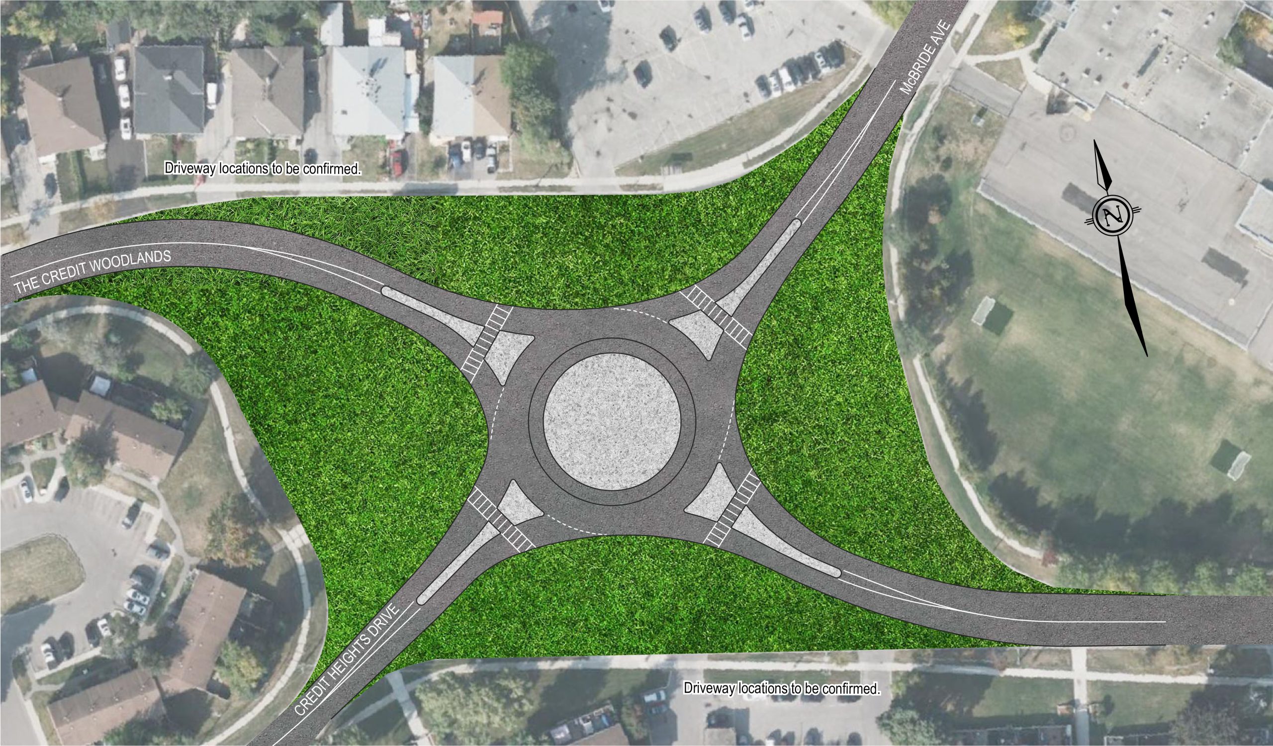
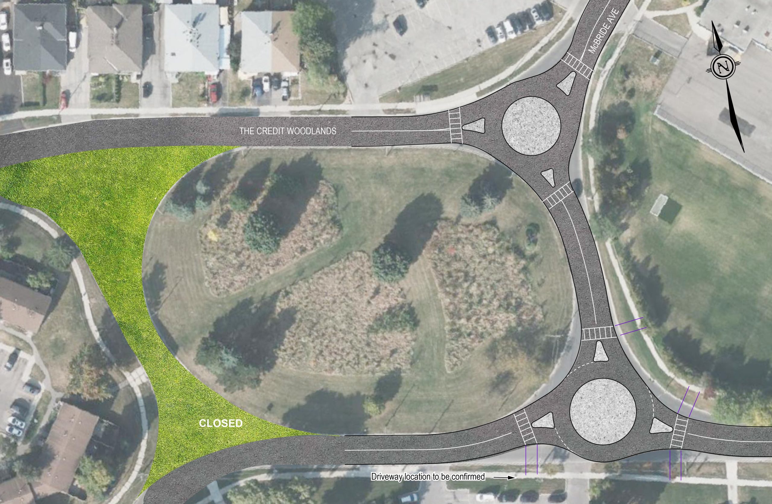
Modified original configuration with two mini-roundabouts design alternative
This alternative features a modification of the original configuration, introducing two-way traffic and two mini-roundabouts on the east leg. This modification uses the same road right-of-way and improves connectivity and traffic flow more efficiently by merging four partial-movement intersections into two full-movement mini-roundabout intersections. A mini-roundabout includes all the modern safety requirements of a full-size roundabout but fits into a circular diameter of 27 metres or less.
This design offers many advantages:
- Makes the road safer
- Reduces the number of vehicles speeding
- Yield control prevents the need for every vehicle to come to a full stop unless necessary
- Keeps the existing right-of-way without widening the current roadway
- Restores free-flow traffic
- Does not have the access restrictions of the roundabout design
- Provides dedicated pedestrian crossings
- Restores the neighbourhood’s character to resemble its original state through changes such as removing coloured pavement
- Provides everyone with access to the existing green space, which could be developed in the future to benefit the community
Selected design
The City has chosen the modified original configuration with two mini-roundabouts design alternative after completing a thorough review of the benefits and potential impacts on the community. This is the only design alternative that is technically feasible and meets the criteria developed from resident feedback. More information about the selected design will be provided as the project progresses.
Questions and answers about the original roadway and different designs
To determine if it’s safe to maintain the original roadway as it is, we had an independent review done. The results of the review (completed by non-City-related professionals) showed that the design doesn’t meet today’s safety standards and several other concerns:
- The original configuration allows vehicles to travel at high speeds, making the roadway less safe to use.
- The lack of controlled crossing facilities for pedestrians and cyclists makes crossing the street inaccessible.
- Although there are yield signs, because the road is wide enough for two lanes, drivers don’t get clear visual cues to yield to cars already in the rotary when entering.
- Drivers in the rotary may not have a clear enough view to see cars going in and out of the driveways that open directly into the rotary.
- Drivers who don’t know the area well might exit a driveway, into the rotary, thinking there is two-way traffic and end up driving the wrong way.
These are the main features of a roundabout:
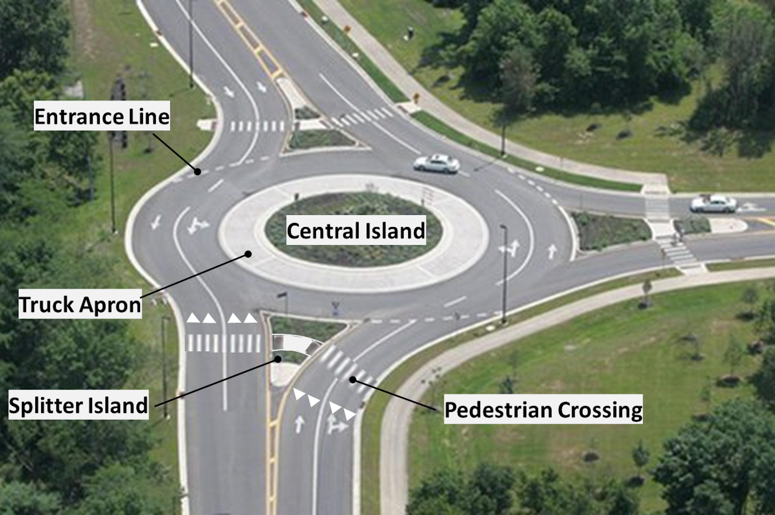
Central Island
A raised area in the centre of the roundabout that the roadway travels around. Central islands are not always circular in shape. Engineering guidelines allow mini-roundabouts to accommodate all types of traffic, including larger trucks and buses.
Splitter island
Raised or painted areas between the entry and exit lanes of an intersection that separate traffic. They make cars slow down and can be designed to give pedestrians a safer, two-stage crossing.
Truck apron
A flat, hard-surfaced part of a central island next to the main road inside the circulatory roadway, with a low-curb that trucks can drive over if needed. They can also be placed on the outside of the circulatory roadway at entrances and exits.
Entrance line
Dashed line that marks the point of entry into the circulatory roadway.
Pedestrian crossings
Pedestrian crosswalks in roundabouts are placed before cars enter and after they exit the roundabout. The splitter island is designed to let pedestrians safely cross through. They should be accessible and easy to use with signs, slopes and textured surfaces.
The main differences between a roundabout, mini-roundabout, traffic circle and rotary are the size, the speed vehicles can travel, and what they’re use for.
Roundabout
- A modern circular intersection where vehicles go counter-clockwise around a central island.
- Vehicles entering the roundabout must yield to traffic already in the roundabout.
- Has specific geometric design and traffic control safety features that improve safety and traffic flow.
Mini-roundabout
- A smaller roundabout but with fully traversable central and splitter islands. This means that large vehicles (such as buses and large trucks) can safely drive over parts of the central and splitter islands when going through the mini-roundabout.
- Commonly used tight spaces or in low-speed urban environments, where a typical single-lane roundabout can’t be placed.
Traffic circle
- An old-style circular intersection typically constructed in urban areas.
- Often equipped with traffic signals or stop signs to control one or more entries, or to facilitate high pedestrian volumes.
- Statues or monuments are often located within the large central island.
- Typically have smaller entry angles that allow for higher speeds at entry.
- May have splitter islands, and may permit parking in the circle.
Rotary
- A large circular intersection designed for high-speed traffic.
- Often has multiple lanes and long entry and exit points, making them larger and thus increasing collision risks. Some rotaries can be up to 100 metres in diameter (the Bert Fleming Park rotary average diameter was nearly 110 metres).
- Some rotaries may prioritize drivers entering the rotary, causing congestion and safety concerns. Historically, the Bert Fleming Park rotary has given priority to entering traffic at some (but not all) of the entrances, which introduces safety concerns, especially for drivers unfamiliar with the area.
Implementing a single roundabout is not feasible due to several significant impacts:
- Driveway access for existing residents would be compromised.
- The cost would be significantly high.
- The City would be unable to complete construction before the project deadline (Fall 2025).
Various placement options for the roundabout were considered, including shifting it northward or southward. However, none of these options met the necessary technical feasibility requirements.
Project updates
Selected design
Based on the analysis by City staff and its engineering consultant, the City has selected the design alternative that involves modifying the original configuration. The design features two-way traffic and two mini-roundabouts on the east leg.
This design was selected because it meets safety and operational requirements and does not impact Bert Fleming Park. It also appropriately balances the community’s desire for free-flow traffic conditions, appropriate traffic speed and safe pedestrian crossings.
The Sharing Lanes project committed to a two-year timeline, which aligns with the need for road rehabilitation. The engineering consultant that completed the independent review has initiated the design work, and City staff are collecting comments for additional considerations to be addressed during implementation.
Construction updates
Information about upcoming and ongoing construction work will be available on this page when available.
Questions and answers about the future of The Credit Woodlands
The Credit Woodlands has been identified as a roadway that would benefit from traffic calming measures due to concerns from local residents and data confirming speeding issues. A preliminary plan is being developed for review by the local Ward Councillor and the impacted residents.
As part of this process, City staff will aim to address speeding concerns and coordinate the work with future improvements to the roadway around Bert Fleming Park.
About traffic calming
Traffic calming refers to physical measures installed to improve safety for road users, particularly by reducing speeding and encouraging safer driving. These measures can be retrofitted on existing roadways or implemented as part of a redesign project.
The City adheres to its Traffic Calming Policy, which outlines the types of roadways and conditions where traffic calming would be considered. It also specifies the process for traffic calming projects, including the requirement for public consultation before staff recommend a project.
Bert Fleming Park spans 7,106 square metres (approximately 1.76 acres), and includes open passive space, naturalized areas and trees.
Historically, the park was not easy for the public to use because it lacked access points that pedestrians can use.
The 2024 Parks, Forestry and Environment Plan aims to make it easier for people to access parks by creating better connection points. The City is interested in reviewing potential improvements to Bert Fleming park to enhance its functionality and usability.
Based on the outcome of The Credit Woodlands Integrated Road Project, the City’s Parks, Forest and Environment staff will consider further developments of the park by consulting with local residents. The long-term vision for the park is to make it easier for park users to access, expand its functionality and provide opportunities for park programming.