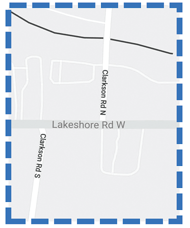
Study area
Lakeshore Road West, Clarkson Road North and Clarkson Road South intersection study area. The study was conducted as a Schedule B project under the Municipal Class Environmental Assessment (October 2000, as amended in 2015), which is approved under the Ontario Environmental Assessment Act.
The study recommends phasing the improvements at the intersection by implementing an interim preferred solution in the short to medium term and a preferred solution in the longer term. The recommended improvements include:
- Interim Preferred Solution: Installation of a raised median between the intersections and provision of side-by-side left-turn lanes
- Preferred Solution: Realignment of Clarkson Road North opposite Clarkson Road South to create a single four-leg intersection.
A Project File Report (PFR) has been prepared to document the study process, consultation efforts and recommended plan. A Notice of Completion placed the PFR on public record for a 45-day review period from October 13, 2022 to November 28, 2022. The PFR is available for download in the Project Documents Selection below.
Please review the Notice of Completion in the Project Notices Section for details on how to provide comments or questions on the PFR before November 28, 2022.
Project documents
- Appendix A – Traffic Operations and Safety Reports
- Appendix B – Cultural Heritage Report
- Appendix C – Stage 1 Archaeological Assessment Report
- Appendix D – Natural Environment Assessment Report
- Appendix E – Arborist Report and Tree Inventory
- Appendix F – Stormwater Management and Drainage Report
- Appendix G – Phase 1 Environmental Site Assessment Report
- Appendix H – Roundabout Screening
- Appendix I – Detailed Evaluation
- Appendix J – Notice of Study Commencement
- Appendix K – Public Information Centre #1
- Appendix L – Public Information Centre #2
- Appendix M – Public Information Centre #3
- Appendix N – Correspondance Record
- Appendix O – Indigenous Community Engagement
- Appendix P – Preliminary Design Plan – Interim Preferred Solution
- Appendix Q – Preliminary Design Plan – Preferred Solution
- Appendix R – Noise Report
- Appendix S – Utility Conflict Plan – Interim Preferred Solution
- Appendix T – Preliminary Cost Estimates
- Appendix U – Air Quality Assessment
- Appendix V – Tree Preservation Plan and Landscape Plan
- Appendix W – Lighting Evaluation Report
Previous Public Information Centres
Our Introductory Public Information Centre (PIC) #1 was held online from December 3 to December 31, 2020. This PIC provided an opportunity for participants to learn about the project, provide input on the key issues and concerns along the study corridor and share ideas with the project team. The commenting period for PIC #1 has now closed.
Public Information Centre (PIC) #2 was held online from November 10 to December 10, 2021. This PIC provided information on the evaluation of alternative solutions, preliminary preferred alternative and next steps for the project. Additionally, PIC #2 included a virtual Q&A meeting on Wednesday, November 24, 2021 where attendees had opportunity to provide feedback and pose questions to the Project Team.
The commenting period for PIC #2 has now closed.
Public Information Centre (PIC) #3 was held online on April 27, 2022. This PIC provided updates on further refinements to the preferred solution presented at PIC #2 and next steps for the project.
The commenting period for PIC #3 has now closed.
